


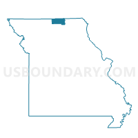
Elm Voting District, Putnam County, Missouri
About
Outline

Summary
| Unique Area Identifier | 609494 |
| Name | Elm Voting District |
| County | Putnam County |
| State | Missouri |
| Area (square miles) | 78.16 |
| Land Area (square miles) | 78.16 |
| Water Area (square miles) | 0.00 |
| % of Land Area | 100.00 |
| % of Water Area | 0.00 |
| Latitude of the Internal Point | 40.40566840 |
| Longtitude of the Internal Point | -92.77199400 |
Maps


Graphs
Select a template below for downloading or customizing gragh for Elm Voting District, Putnam County, Missouri


Neighbors
Neighoring Voting District (by Name) Neighboring Voting District on the Map
- Glenwood Voting District, Schuyler County, MO
- Grant Voting District, Putnam County, MO
- Greentop Voting District, Schuyler County, MO
- Liberty Voting District, Putnam County, MO
- Novinger Voting District, Adair County, MO
- Pennville Voting District, Sullivan County, MO
- Richland Voting District, Putnam County, MO
- West Prairie Voting District, Schuyler County, MO
Top 10 Neighboring County Subdivision (by Population) Neighboring County Subdivision on the Map
- Nineveh township, Adair County, MO (1,289)
- Prairie township, Schuyler County, MO (1,119)
- Salt River township, Schuyler County, MO (728)
- Elm township, Putnam County, MO (579)
- Morrow township, Adair County, MO (431)
- Glenwood township, Schuyler County, MO (368)
- Richland township, Putnam County, MO (259)
- Liberty township, Putnam County, MO (218)
- Grant township, Putnam County, MO (210)
- Buchanan township, Sullivan County, MO (174)
Top 10 Neighboring Place (by Population) Neighboring Place on the Map
Top 10 Neighboring Unified School District (by Population) Neighboring Unified School District on the Map
- Kirksville R-III School District, MO (22,063)
- Putnam County R-I School District, MO (4,843)
- Schuyler County R-I School District, MO (4,565)
- Adair County R-I School District, MO (1,872)
- Green City R-I School District, MO (1,731)
Top 10 Neighboring State Legislative District Lower Chamber (by Population) Neighboring State Legislative District Lower Chamber on the Map
Top 10 Neighboring State Legislative District Upper Chamber (by Population) Neighboring State Legislative District Upper Chamber on the Map
Top 10 Neighboring 111th Congressional District (by Population) Neighboring 111th Congressional District on the Map
Top 10 Neighboring Census Tract (by Population) Neighboring Census Tract on the Map
- Census Tract 9502, Adair County, MO (3,019)
- Census Tract 9601, Putnam County, MO (2,725)
- Census Tract 4702, Schuyler County, MO (2,356)
- Census Tract 4801, Sullivan County, MO (2,124)
Top 10 Neighboring 5-Digit ZIP Code Tabulation Area (by Population) Neighboring 5-Digit ZIP Code Tabulation Area on the Map
- 63565, MO (3,805)
- 63546, MO (1,715)
- 63559, MO (1,420)
- 63561, MO (1,206)
- 63544, MO (818)
- 63541, MO (409)
- 63551, MO (338)
- 63567, MO (192)